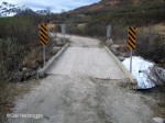
Above treeline the road crosses a crude bridge beyond the Reed Lakes Trailhead where remnants of the last winter snow remain in the creek bed. I photographed beautiful wide vistas of the highland Archangel Valley from the road adding new research material for my original painting files. More tomorrow, Gail Niebrugge, Alaska Artist
Hatcher Pass Archangel Road
June 30, 2007 by Leave a Comment
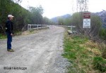
The unmaintained Archangel Road is located just above the Motherlode Roadhouse at mile 15 Hatcher Pass Road, and is closed during the winter. It is a perfect late Spring hike and a great place to scout for scenery to photograph for my research files for future original paintings. More tomorrow. Gail Niebrugge, Alaska Artist
Beaver Ponds Everywhere
June 29, 2007 by Leave a Comment

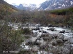
The Gold Mint Trail passes alongside a chain of many active beaver ponds. The calm, clear water created perfect reflections of the surrounding alpine peaks perfect to include in a future original landscape painting. We hiked for two hours and vowed to come back soon for a longer trip. The trail was in very good […]
Gold Mint Trail Follows Little Susitna River
June 28, 2007 by Leave a Comment
The Gold Mint Trail meanders up a beautiful valley and follows the Little Susitna River, eventually ending at the headwaters. It was a crisp, overcast day and the sounds of rushing water and birds chirping filled the air. What a wonderful hike! I found many beautiful landscape scenes to photograph for use in future original […]
Archangel Creek Bridge
June 27, 2007 by Leave a Comment

The well kept Gold Mint Trail crossed the clear flowing water of Archangel Creek with a beautiful bridge built by volunteers using funds raised by junior middle school classes. We were the only people on the trail this morning. The scenery was spectacular. More tomorrow, Gail Niebrugge, Alaska Artist
Hatcher Pass Gold Mint Trailhead
June 26, 2007 by Leave a Comment
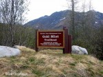
Just 25 miles away is the scenic alpine country of Hatcher Pass, in the Talkeetna Mountains, and the beautifully maintained public recreation area of Alaska State Parks. At this elevation Spring is two weeks behind, so we dressed a little warmer for our morning hike along the Gold Mint Trail. Since the trees were not […]
Crevasse Moraine Trail Markers
June 25, 2007 by Leave a Comment

There is a sign at each junction in the Crevasse Moraine Trail System, showing where you are on a complete map of the area. It is very user friendly and fun to plan as you go. Another post shows the difficulty level of each segment. Some loops are very hilly and others are nearly flat. […]
Palmer Crevasse Moraine Trail System
June 24, 2007 by Leave a Comment
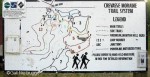
One of the best hiking/skiing trail systems in the Matanuska Valley, Alaska, is the Crevasse Moraine. The scenery is lush, topography varied, and maps are available at the trailhead. Walking is easy and you can custom build your trip as you go by consulting the markers at each junction. We hiked over four miles, the […]
Hatcher Pass Road Summit
June 17, 2007 by Leave a Comment
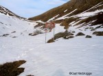
With the summit of Hatcher Pass in sight we had to abandon our hike because the snow was too soft and “punchy”, we would be walking on the surface one minute and suddenly break through the crust and be buried up to our thighs. It was fun and invigorating and will be a great hike […]
Hatcher Pass Road Steep Grade
June 16, 2007 by Leave a Comment

The steep grade to the summit of Hatcher Pass is a good workout, we dressed warm and worked up a pretty good sweat. The two of us were completely alone in this spectacular alpine landscape. Part of the road was covered in snow drifts, but the southern edge was clear and walking was easy. There […]
Hatcher Pass Road Hike
June 15, 2007 by Leave a Comment

The road to Hatcher Pass from Palmer, beyond the Independence Mine is not maintained during the winter. Even though it is May 30 and spring green is everywhere in the valley, the Hatcher Pass road is still covered in snow and closed. We decided it would be a great place to hike since it is […]
West Butte Trailhead
June 10, 2007 by 2 Comments

The trail widened and gradually descended to a trailhead marked “West Butte Trailhead”. No map, no directions, nothing! There we were stranded on the opposite side of the Butte from where we began. To reach our car we had two choices, we could retrace our steps and hike back over the mountain or hike four […]
Butte Trail Bench
June 9, 2007 by Leave a Comment
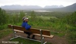
Even though the blowing dust obscured the view, we were protected on the west side of the Butte. This new upgraded section of the trail had lovely benches for hikers pause and rest and soak in the views. I photographed several beautiful scenes that could be used as reference material for original paintings. It was […]
Butte Trail Rope Handrails and Wood Stairs
June 8, 2007 by Leave a Comment

We followed the new trail from the summit and were delighted that it ascended through trees on the wind protected side of the knoll. It is a lovely path with amenities, rope handrails and wood stairs make the climb a joy. More tomorrow, Gail Niebrugge, Alaska Artist
New Surface on the Butte Trail
June 7, 2007 by Leave a Comment
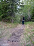
As we explored the summit of the Butte we found a new path covered in a heavy material using a web honeycomb pattern that looks like it will eliminate the erosion that plagued the old route. It seemed strange that we didn’t notice where this path joined the original main trail and that it wasn’t […]
Butte Summit
June 6, 2007 by Leave a Comment

At the top of the Butte the views are awesome and well worth the climb. Today the mountains and glaciers in the distance were obscured by strong winds blowing glacier dust. A 360 degree panorama of glaciers, rivers and rich farmlands can be seen far below, a spectacular sight on a clear sunny day. More […]
Well-Worn Butte Trail
June 5, 2007 by Leave a Comment

After the initial climb the well-worn path is easy to follow, years of use have grooved and eroded a track several feet deep in many places and switchbacks make the ascent easier. The exposed south/east side of the knoll can be very windy, we were often sprayed by blowing dust. More tomorrow, Gail Niebrugge, Alaskan […]
Butte Trailhead Stairs
June 4, 2007 by Leave a Comment

The stairs carved into the hilside are misleading, if you look at the top of the photo you can see the steps end and a very steep, dusty powder trail begins. The climb is 835 ft. and we did it easily in less than 30 minutes. More tomorrow. Gail Niebrugge, Alaska Artist
Palmer Butte Trailhead
June 3, 2007 by Leave a Comment
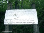
It has been a few years since we’ve hiked the Butte Trail in Palmer, Alaska, it is a pretty straight forward 875 foot climb to the top of a knoll with commanding views at the top. We were surprised to see that passed through privately owned land, because we thought it was a borough trail. […]
Moose Creek Railroad Trail Landslide
May 31, 2007 by Leave a Comment

We finally found a narrow footpath along the bluff above Moose Creek and eagerly began our hike. A short while later we came to a steep gravel bank where high above the rusted iron railroad rails were suspended in the air, hanging like clotheslines. The entire bluff was washed away in a huge landslide and […]